Invest 98L isn't a problem -yet. But it is something we definitely need to be watching here in Southwest Florida.
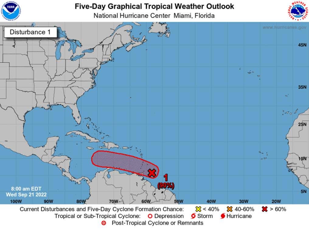
The big news going on right now is Hurricane Fiona. As of this morning's update, it's a Category 4 Hurricane with sustained winds of 130 mph. The truth is, Hurricane Fiona and Tropical Storm Gaston pose no threat to us here in Florida. It's the next one we're watching. Here's the official report from NOAA:
"A tropical wave is producing shower and thunderstorm activity a couple hundred miles east of the southern Windward Islands. The system continues to show signs of organization, and it will likely become a tropical depression within the next couple of days. The disturbance is forecast to move west-northwestward across the southern Windward Islands today and then move toward the central Caribbean Sea later this week. Interests in the Windward Islands should closely monitor the progress of this system as heavy rainfall and gusty winds are affecting these islands. Regardless of development, heavy rainfall is forecast to affect northwestern Venezuela, northeastern Colombia, and the ABC island chain later this week. * Formation chance through 48 hours...high...70 percent. * Formation chance through 5 days...high...90 percent."
Invest 98L is Likely To Become A Strong Storm
It's still too far out to make determinations, but we are definitely in the concern phase for the possibility of something mid next week. Last year's season was nothing, so it's easy to get complacent. Here's our Hurricane Guide for you to look over. Don't start putting up your shutters or filling up gas cans just yet. We're not at that point.
This morning's model runs
The black line is the 'mean' or average. Currently, that's us.
Here's what the radar would look like if the model runs come true
So what do we know about projected strength? The number over the L is millibars. And there's a chart for that.
Saffir-Simpson Hurricane Scale
| Category | Wind speed | Storm surge (height above normal) | Atmospheric pressure (millibars) | Damage |
| 1 | 74–95 mph (119–153 kph) |
4–5 ft (1.2–1.5 m) |
>979 | Minimal: No real damage to buildings. Damage to unanchored mobile homes. Some damage to poorly constructed signs. Some coastal flooding and minor pier damage. |
| Examples: Cindy and Ophelia (2005) | ||||
| 2 | 96–110 mph (154–177 kph) |
6–8 ft (1.8–2.4 m) |
965–979 | Moderate: Some damage to building roofs, doors, and windows. Considerable damage to mobile homes. Damage to piers from flooding. Small craft in unprotected moorings may break their moorings. Some trees blown down. Evacuation of some shoreline residences and low-lying areas required. |
| Example: The Perfect Storm (1991), Hurricane Isabel (2003) | ||||
| 3 | 111–130 mph (178–209 kph) |
9–12 ft (3–4 m) |
945–964 | Extensive: Some structural damage to small residences and utility buildings. Large trees blown down. Mobile homes and poorly built signs destroyed. Flooding near the coast destroys smaller structures with larger structures damaged by floating debris. Terrain may be flooded well inland. Evacuation of low-lying residences within several blocks of the shoreline may be required. |
| Examples: Dennis, Katrina, Rita, and Wilma (2005) | ||||
| 4 | 131–155 mph (210–249 kph) |
13–18 ft (4–5.5 m) |
920–944 | Extreme: More extensive failure on non-bearing, exterior walls with some complete roof structure failure on small residences. Major erosion of beach areas. Terrain may be flooded well inland. Massive evacuation of residential areas as far inland as 6 mi (10 km) may be required. |
| Example: Galveston Hurricane of 1900 | ||||
| 5 | >155 mph (249 kph) |
>18 ft (5.5 m) |
<920 | Catastrophic: Complete roof failure on many residences and industrial buildings. Some complete building failures with small utility buildings blown over or away. Flooding causes major damage to lower floors of all structures near the shoreline. Massive evacuation of residential areas on low ground within 5 to10 mi (8 to 16 km) of the shoreline may be required. |
| Example: Andrew (1992) | ||||
Can someone just explain this in an easy to understand way?
This guy does an amazing job.
What to do now?
Nothing, really. The storm is still developing and there's a lot of factors at play. Especially that cold front that Mike talks about in the video. I actually began my prep last night by buying dog food and vodka. Now we just wait to see what happens.
Here's our guide, just in case
2022 Hurricane Central – Preparedness Guide


Hurricane Central - Preparedness Guide gives you the updated information you may need in the event of a hurricane. Just because 2021 was a quiet year for storms doesn't mean we can ever let our guard down. This guide is sponsored by local businesses here in SWFL. Gavin's Ace Hardware, Sean King Law, and Powerhouse Home Services.


HURRICANE CONTACT NUMBERS
EMERGENCY OPERATION CENTERS
CONTRACTOR INFORMATION
POWER COMPANIES
ONLINE RESOURCES
Preparing Your Home
Shelters - Lee County
Emergency Operations Center 239-533-0622
Bonita Springs YMCA – Bonita Springs
Island Coast High School – Cape Coral
Estero Recreation Center – Estero
Germain Arena – Estero
South Fort Myers High School (Pet Friendly) – Fort Myers
E. Lee County High School (Pet Friendly) – Lehigh Acres
Harns Marsh Elementary School – Lehigh Acres
Harns Marsh Middle School – Lehigh Acres
Mirror Lakes Elementary School – Lehigh Acres
Varsity Lakes Middle School – Lehigh Acres
Veterans Park Recreation Center – Lehigh Acres
Shelters - Collier County
Emergency Operations Center: 239-252-3600
Highlands Elementary School – Immokalee
Immokalee Friendship House – Immokalee
Immokalee High School – Immokalee
Immokalee Middle School – Immokalee
Pinecrest Elementary School – Immokalee
Village Oaks Elementary – Immokalee
Barron Collier High School – Naples
Big Cypress Elementary – Naples
Corkscrew Elem/Middle School – Naples
Cypress Palm Middle School – Naples
Golden Gate Intermediate School – Naples
Golden Gate Middle School – Naples
Golden Gate High School – Naples
Golden Terrace Intermediate School – Naples
Gulf Coast Intermediate School – Naples
Gulf Coast High School – Naples
Laurel Oak Elementary School – Naples
Lely High School – Naples
Mike Davis Elementary School
Naples High School
North collier Regional Park (Pet Friendly) – Pre-registration is required
North Naples Middle School
Oakridge Middle School
Palmetto Ridge High School – Special Needs
Pelican Marsh Elementary
Sable Palm Elementary School
St. Matthews House
Veterans Community Park
Vineyards Elementary School
Shelters - Charlotte County
Emergency Operations Center: 941-833-4000
*All Charlotte County shelters are now Pet Friendly
Lemon Bay High School – Englewood
Myakka River Elementary School – Englewood
Kingsway Elementary School – Port Charlotte
Liberty Elementary School – Port Charlotte
Meadow Park Elementary School – Port Charlotte
Murdock Middle School – Port Charlotte
Port Charlotte High School – Port Charlotte
Port Charlotte Middle School – Port Charlotte
Sallie Jones Elementary School -Punta Gorda
South County Regional Park -Punta Gorda
L.A. Ainger MIddle School – Rotonda
Vineland Elementary School – Rotonda
Shelters - Hendry County
Emergency Operations Center: 863-674-5400
Central Elementary School – Clewiston
Clewiston High School – Clewiston
Clewiston Middle School (Primary Shelter) – Clewiston
Eastside Elementary School – Clewiston
Westside Elementary School – Clewiston
Country Oaks Elementary School – LaBelle
LaBelle Elementary School – LaBelle
LaBelle High School – LaBelle
LaBelle Middle School (Primary Shelter) – LaBelle
Shelters - Glades County
Emergency Operations Center: 863-946-6020
Buckhead Ridge VFW – Buckhead Ridge
Maple Grove Baptist Church – Lakeport
Glades County Health Department (Special Needs) – Moore Haven
Moore Haven High School – Moore Haven
Muse Community Assn. – Muse
West Glades Elementary (Special Needs) – Muse
Shelters - Desoto County
Emergency Operations Center – 863-993-4831
Desoto Middle School -Arcadia
South Florida State College (Special Needs) -Arcadia
Terminology - Hurricane Watch

Hurricane watch = conditions possible within the next 48 hrs.
Steps to take:
Terminology - Hurricane Warning

Hurricane warning = conditions are expected within 36 hrs.
Steps to take:
Follow the hurricane timeline preparedness checklist, depending on when the storm is anticipated to hit and the impact that is projected for your location.


After The Hurricane


